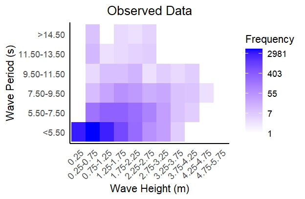
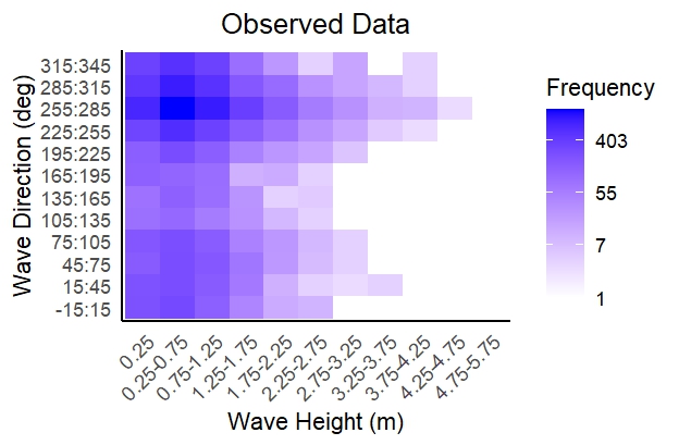
Field measurements of wind and wave data were made available by the Public Works Department of Cyprus through a study conducted for the “Coastal zone management for Cyprus”. Measurements on wave height, period and direction were made through ship observations for the period of 1961 to 1980 for the open sea of Cyprus (Figure 5).
Figure 5: Wave height (m) paired with wave period (s) and their frequency of occurrence for Southern Cyprus, demonstrating that the highest frequencies belong to wave heights below 1.25 m with wave periods of less than 5.5 seconds (top). Wave height (m) paired with wave direction (deg) and their frequency of occurrence for Southern Cyprus, demonstrating that the highest frequencies belong to wave heights below 1.25 m with wave direction in the range of 255 to 285 degrees (bottom).
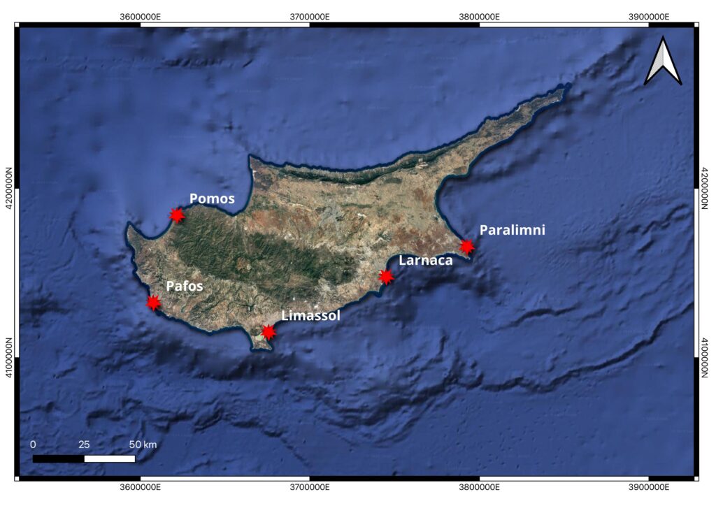
The Department of Lands and Surveys (DLS) in collaboration with the Cyprus University of Technology (CUT) created the national tide gauge network of the Republic of Cyprus, known as PYTHEAS. PYTHEAS currently includes five stations positioned along the coastline of government-controlled areas in Cyprus (Figure 6). The network was established to assist maritime spatial planning studies required by the THALCHOR2 project, as well as to support hydrographic and mapping activities, and to facilitate research on sea-level rise and associated risks. The main objective of the network was the determination of local tidal data in Cyprus using sea-level measurements for the period of 2017 to 2019.
Figure 6: PYTHEAS network for the Republic of Cyprus.
The graph below represents daily water level data from the observation station in Limassol covering the period from January 2018 to November 2019. The observed water level varies over time, with a maximum recorded level of 0.378 m and a minimum level of -0.5 m. The observed trends suggest a seasonal pattern, with frequent peaks and troughs, indicating variability in water levels.
Figure 7: Daily water levels for the area of Limassol from January 2018 to November 2019.
Danezis, C., Nikolaidis, M., Mettas, C., Hadjimitsis, D. G., Kokosis, G., & Kleanthous, C. (2020). Establishing an Integrated Permanent Sea-Level Monitoring Infrastructure towards the Implementation of Maritime Spatial Planning in Cyprus. Journal of Marine Science and Engineering, 8(11), 861. https://www.mdpi.com/2077-1312/8/11/861